


Changes in HelpTerrains
Editor Comment
spelling
Revision Differences of Revision 18
[TOC] ¶¶
Terrains are one of the base graphics in widelands. This page describes how they are implemented and should help with creating new terrains. 
In the end you'll find how to get your terrain in the game. 
# Properties of the terrain patterns 
The patterns for terrains do have some restrictions: 
1. the width and height has to be 64 pixel 
2. they must be color indexed 
3. they couldn't get transparent areas 
# Squared patterns as triangles 
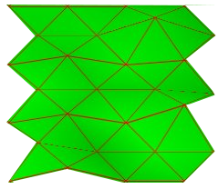
The surface of the widelands screen consists of a lot of triangles: 
See [geometry](https://wl.widelands.org/docs/wl/geometry/) for more about this issue.
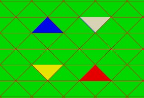
The four colors represent the triangles in which the pattern is splitted while rendering. Only one of those triangles are displayed for each
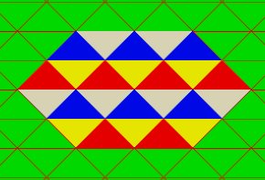
Note that the red and white triangles of the original pattern are assembled from two patterns to get one big red and one big white triangle. In the above picture the patterns are knowingly spread, to help distuinguish the single patterns
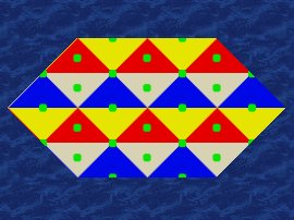
The patterns do have allways the same area where they adjoin: 
Testpattern 2 | Result 
---------- | ---------- 
 |  
This is importand to create terrain patterns which do not have visible edges if the patterns of the same type adjoin. 
# Implementing in the game 
This section describes how the terrains patterns are imp
## Dithering 
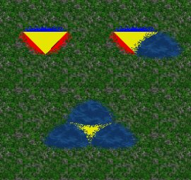
Different types of terrains do not have hard edges if they adjoin. This is made with dithering, a technique which blur the edges from one terrain type to another. Dithering could result in different results: 
The above left example shows, that the testpatterns overlaps with the meadow terrain. The right one shows the opposit: The blue terrain overlaps the testpattern. If we use the blue terrain for all edges, the visible area of the testpattern shrinks drastically. Who decides which terrain dither over the other? 
### Dithering configuration 
The dithering is configured in the file `path/to/gamedata/widelands/world/terrains/init.lua` (for linux-systems) with the variable `dither_layer`. 
**This settings are valid for the whole game. It is not possible to change this value during map creation or adjust it for each map different!** 
Each terrain has its own dither_layer value. Terrains with higher values let the terrain dither over terrains with lesser values. Is the dither_layer value the same, no dithering is made. Examples which are used in chapter [dithering](#dithering): 
Terrain | dither_layer | consequence 
-------- | --------- | ------------ 
testpattern | 220 | This overlaps the meadow terrain 
meadow | 120 | This pattern is covered by the testpattern 
blue | 240 | This terrain overlaps meadow and the testpattern 
## Defining the kind of terrain 
There are several possibilities to explain what "kind of" a terrain is. F.e. one could define a terrain as "arable" which means that buildings could be build. This definition is made by the `is
Value | Meaning 
--------| ------------- 
"arable" | Allows building of normal buildings and roads 
"mineable" | Allows building of mines and roads 
"walkable" | Allows building of roads only 
"water" | Nothing can be built here, but ships and aquatic animals can pass 
"dead" | Nothing can be built here (not even immovables), and nothing can walk on it 
"impassable" | Nothing can be built here, and nothing can walk on it 
#### A side note on programming 
This values defines a description for a terrain, but most of the calculation in widelands do not depend on terrains, they depend on the nodes where the terrains adjoin. Every node has 6 terrains around it. Depending on this terrains the node becomes f.e. walkable, arable or mineable. 
# Flags, buildings and immovables 
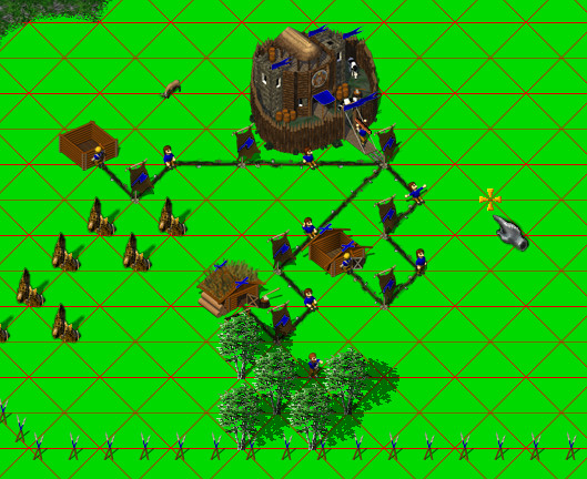
All of the graphical things in widelands is placed not on the terrain itself, they are placed on the edges where the terrains adjoin. Buildings, roads, trees,... animals are walking along the edges: 
# How to get your terrain into the game 